Indirect Detection of Permafrost Degradation in Eastern Alaska Using Modis and Landsat Data
Background
Permafrost is defined as ground that remains at or below 0℃for two or more consecutive years. Rising temperatures in polar regions due to climate change are causing significant changes in landscapes dominated by permafrost. The extent and severity of these changes have previously been hard to quantify due to the remote nature of the area of permafrost for the data collection process, but modern advances in satellite remote sensing technology have allowed a plethora of relevant data to be easily accessed and used for analysis. In this study, satellite imagery is used to detect changes in the landscape that indicate melting permafrost in Eastern Alaska. Three main metrics are the focus of the review: land surface temperature (LST), vegetation cover, and the annual maximum extent of water bodies. Indexes such as Normalized Difference Vegetation Index (NDVI), Enhanced Vegetation Index (EVI), and Modified Normalized Difference Water Index (MNDWI) are used to generate the results, culminating in a multivariate analysis of the change in permafrost in Eastern Alaska over the study period of 2000 – 2015. Results show that the vegetation greening trend in Eastern Alaska considering the overall change trend of EVI values are indicators of permafrost thawing in these years. Besides, based on Sen’s slope, surface temperatures have been increasing over time, thus confirming that rising surface temperature is the driving force of permafrost melting.
Dataset
The study area lays between Fort Yukon and Fairbank in Eastern Alaska, USA. This inland area is located in the continental subarctic region, which is covered with a large amount of continuous as well as discontinuous permafrost all year round. The typical climate for our study area has long cold winters and short warm summers, with the lowest temperature ranging from -30℃ in winter and to -15℃ in summer (The Alaska Climate Research Center, 2018). Studies have shown that permafrost degradation is severe in inland Alaska causing shifts in land cover types (Jorgenson et al., 2001). Since one of our study objectives is to detect how the land cover feature changes related to the permafrost degradation, a region that has a sufficient amount of vegetation cover, water bodies, as well as different landforms (for temperature comparing purposes) has been selected.
Overview
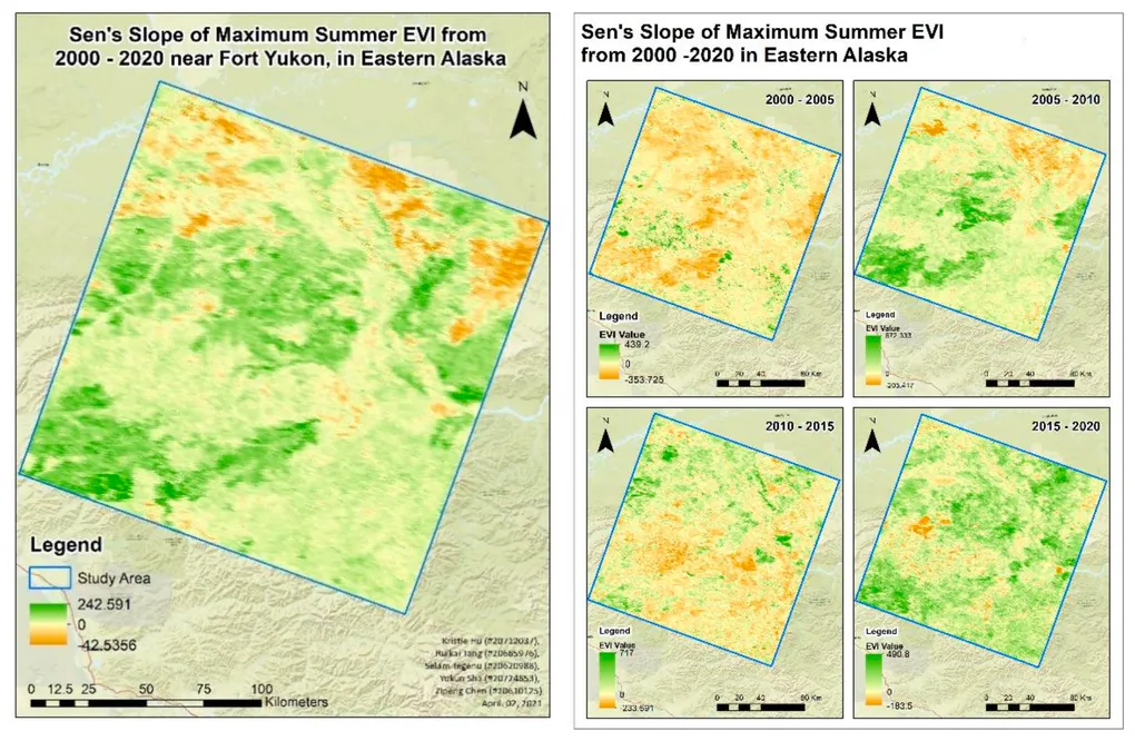
This project quantifies permafrost degradation in Eastern Alaska by inferring subsurface thaw from surface-level satellite signals.
Using MODIS and Landsat time series, I analyzed coordinated changes in vegetation greenness, land surface temperature, and surface water extent to detect long-term thaw patterns.
Key Results
- Widespread vegetation greening dominates the region, consistent with active-layer deepening.
- Land surface temperature shows a persistent upward trend, confirming warming as the primary driver.
- Surface water extent increased (~1.08%), indicating thermokarst development and thaw-related ponding.
- Independent indicators converge, strengthening confidence in inferred permafrost degradation.
This work demonstrates how remote sensing can reliably infer underground permafrost dynamics at scale, enabling climate monitoring in regions where field instrumentation is sparse or infeasible.
Future work includes machine-learning–based land-cover inference (RF, ANN) and 3D geophysical integration (GPR, ERT) to improve subsurface resolution and predictive power.
Presented at FIG Congress 2022 · Warsaw, Poland